Objectives:
The map is tilted...
<the story>
Even USGS talks about it. (in a paper about Digital Raster Graphics)
Some reminders about projections:
A spatial reference system usually includes (although NGS now calls the geodetic reference system a "spatial reference system" just to confuse us all!) :
The parameters lay out the geometry of the developable surface choice.
boil down to conventional choices of projection parameters - thus a kind of metadata; Overview Peter Dana Geographer's Craft site; some examples for SPC zones. A site with a European geography of reference systems (Voser).
Zone of standardized system (UTM
counts from Date Line eastward- we are in Zone 10)
State Plane zones have multiple numbering systems (alphabetic
state or FIPS codes...)
state plane zones are aggregates of counties, eg. central
Texas.
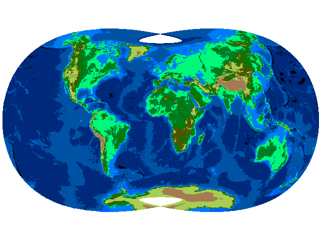
Most multi-zone states have a secret (usually unoffical) projection that covers the whole state. In Wisconsin, it is a TM zone positioned on the split between two zones in UTM (90 West), in Oregon, they have a special compromise Lambert rather openly adopted (including a set of error analysis, the area error image).
Washington has the practice of extending South Zone to the North without any official sanction...
Official Coordinates for Washington State (RCW (the server) , Text (partially converted of Title 58 Chapter 20)
Australia runs multiple datums and projections, and has some
great conversion
software live.
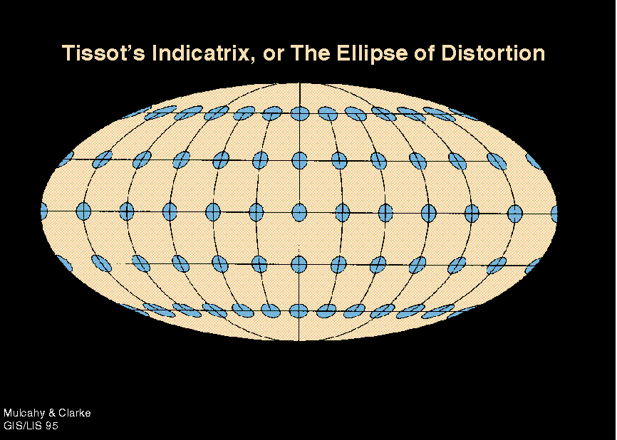
Tissot's
Indicatrix deformation from ellipse created by tiny circles
projected [1881]
basically obtained by a differential of mapping equations [yes,
calculus]
While Tissot had a geometric connection, Laskowski (1989) in Accuracy
of Spatial Databases shows how to obtain more easily through
Singular Value Decomposition [SVD] (obtained from Taylor expansion
of mapping equations) (Laskowski's
personal favorite)
See some examples of the Indicatrix for standard projections (MICROCAM);
research on projection error (Hunter College - dead project)
Reenforcing how to change the projection and datum of geographic information files using ArcGIS 8
Projection Wizard under Arc Toolkit; Gene Martin's Boot Camp (460)
Obtain a collection of coverages, shape files or whatever.
Examine their projection documentation (sometimes nonexistent...)
Learn to read the tea leaves: a form of data quality assessment
(How to TELL what projection it must be in...)
Running the wizards
menus and forms to fill in...
At a minimum, you should know how to convert something to/from NAD27 => NAD 83 (or HPGN), and between UTM and State Plane. These are the regular things you will do over and over. Look at the default items which are pre-recorded