Objectives of PART 2:
<see also supporting resources for this lecture>
GIS: a buzz-word, a movement out of control of the originators.
Hence, the attempts at formal definition will not succeed.
< more on Resources page>
"A geographic information system (GIS) is a computer-based tool for mapping and analyzing things that exist and events that happen on Earth. GIS technology integrates common database operations such as query and statistical analysis with the unique visualization and geographic analysis benefits offered by maps. These abilities distinguish GIS from other information systems and make it valuable to a wide range of public and private enterprises for explaining events, predicting outcomes, and planning strategies." (ESRI 1997)
"An information system that is designed to work with data referenced by spatial or geographic coordinates. In other words, a GIS is both a database system with specific capabilities for spatially-referenced data, as well as a set of operations for working with the data." (Star and Estes 1990, p.2-3)
"A system of hardware, software, data, people, organizations and institutional arrangements for collecting, storing, analyzing, and disseminating information about areas of the earth." (Dueker & Kjerne, 1989)
US Geological
Survey's definition; note the links (originally a GIS poster)
for integration
and What's special
ESRI
(they tried to hide it, but it was still there in their glossary)
www.gis.com (a front for ESRI) has a folksy definition
focused on the toolkit and one tool in particular... and a HUGE
slide show,
quite revealing
<for more definition examples, see Resources>
Geographic Information Science
GIS ... has done much to remove the traditional isolation between photogrammetry, remote sensing, geodesy, cartography, surveying, and geography (one could add to this list computer science, operations research, spatial statistics, cognitive science, behavioral psychology, and any other discipline with interests in the generic issues of spatial data). In an earlier paper, I argued that these were the disciplines of geographic information science, and that it made more sense for the research community to decode the GIS acronym in this way, focusing on the generic issues of spatial data, rather than on the limited solutions offered by today's geographic information system products. (Goodchild 1995, p. 42 emphasis in original)
Forer and Unwin (1998) have recently proposed "Geographic
Information Studies" as a means to treat "the
considerable social, legal and ethical issues".
Try as they might, GIS still stands for Systems.
"Just a tool", or a way of life - a different way of
looking at the world?
From Exploring GIS page 13
GIS: The organized activity by which people
These activities reflect the larger context (institutions and
cultures) in which these people carry out their work. In turn,
the GIS may influence these structures.
Geographic Information System (GIS): Organized activity by which people measure and represent geographic phenomena then transform these representations into other forms while interacting with social structures.
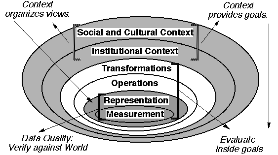
This definition is derived from the ring diagram [concentric
concerns of this course].
A definition can be used to exclude others, to establish firm barriers to entry, to accentuate differences... Definitions are connected to the practice of power. In the early period, it is important to establish what is a "real" GIS, contrasting with other kinds of IS.